Open-Access Visual Search Tool for Satellite Imagery – NVIDIA Technical Blog News and tutorials for developers, data scientists, and IT admins 2025-07-09T19:00:00Z http://www.open-lab.net/blog/feed/ Brad Nemire <![CDATA[Open-Access Visual Search Tool for Satellite Imagery]]> https://news.www.open-lab.net/?p=7420 2022-08-21T23:38:01Z 2016-05-26T16:23:40Z A new project by Carnegie Mellon University researchers provides journalists, citizen scientists, and other researchers with the ability to quickly scan large...]]> A new project by Carnegie Mellon University researchers provides journalists, citizen scientists, and other researchers with the ability to quickly scan large...

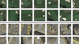
A new project by Carnegie Mellon University researchers provides journalists, citizen scientists, and other researchers with the ability to quickly scan large geographical regions for specific visual features. Simply click on a feature in the satellite imagery �C a baseball diamond, cul-de-sac, tennis court �C and Terrapattern will find other things that look similar in the area and pinpoint them��

Source

]]>
0
���˳���97caoporen����